
JPS is multi-disciplined project services firm which delivers results by combining time tested methodology and technological innovation to serve our client’s needs, budget and schedule. Click on an icon below to get more detail on our individual services.
PROJECT PLANNING, PERMITTING AND MANAGEMENT
JPS provides a wide offering of services pertaining to project planning, permitting, oversight and management ensuring on-time and on-budget completion of projects both large and small
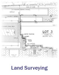
LAND SURVEYING
Under the supervision of licensed Land Surveyors, JPS uses a combination of conventional instrument, robotic technology, Global Positioning Systems and drone technology to perform all types of land surveys. Deliverables are customized to our clients needs and specification using CAD and GIS platforms.
AERIAL MAPPING AND LASER SCANNING
Employing both drones equipped with,high resolution photography, video and LiDAR capability and tripod mounted 3D scanning technology to produce Digital Elevation Models (DEM), CAD and GIS contour map layers and ortho-rectified aerial photography. We also work with strategic partners with manned aircraft for larger scale mapping projects.
CIVIL ENGINEERING
Under the supervision of a licensed Civil Engineer, JPS helps clients determine best and highest use through the Master Planning process and feasibility studies. In the design phase we provide safe, efficient and effective designs of design of site grading, roadway and parking areas, storm and waste water management; all done with constant awareness of project schedule and budget.
CONSTRUCTION SUPPORT
Once you break ground JPS will bring knowledge and technology to the table to help guide your project to a successful completion with Construction Management, Inspection and As-built Services; to name a few.